On this page
- In Brief
- Gili Putih at a Glance
- Gili Putih Began as a Bare Pile of Sand the Village Came to Enjoy
- Sumberkima Is Named After a Spring Found in Kima Shells
- Reach It by Boat from Bangsal, or on Foot at Low Tide
- The Sea Around Gili Putih Is Being Replanted with Coral
- Fishermen Still Work the Water, and Hold a Contest Here Each August
- How to Fit It In
- Practical Notes
- FAQ
- Sources
In Brief
Gili Putih is a sandbar of white sand in the sea off Sumberkima, a village in Gerokgak district on Bali's north-west coast. At low tide it spreads to between one and three hectares. At high tide a few hundred square metres stay dry.
Most people cross by boat from Bangsal harbour in Sumberkima, a ride of 10 to 15 minutes. At low tide you can also walk out from Pegametan beach, about 1.5 kilometres, according to Buleleng's tourism office.
A village tourism group looks after the sand, and the water around it is being replanted with coral.
Gili Putih at a Glance
- What it is: a natural sandbar of white sand, built up by currents and waves
- Where: off Sumberkima village, Gerokgak, Buleleng (map pin from the regency's listing)
- Size: one to three hectares at low tide, a few hundred square metres at high tide
- By boat: from Bangsal harbour (Sumberkima Bay) in the hamlet of Mandar Sari, 10 to 15 minutes
- On foot: at low tide only, about 1.5 km from Pegametan beach
- Looked after by: Pokdarwis Kima Bahari Mandasari, the village tourism group
- In the water: coral replanting by a Sumberkima conservation group
- From Gilimanuk: about half an hour's drive to Bangsal harbour
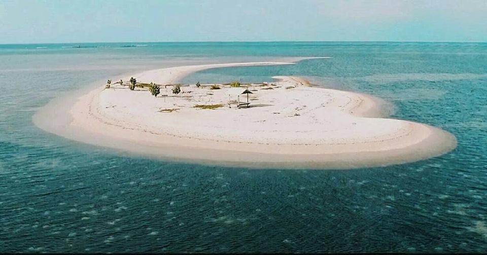 Gili Putih from the air, a hook of white sand off Sumberkima. Photo: Palm Living.
Gili Putih Began as a Bare Pile of Sand the Village Came to Enjoy
Gili Putih formed on its own, from sand carried in by currents and waves.
The customary village of Sumberkima describes it that way in its social profile, published by the Bali provincial government in 2025. Before it had a name, Buleleng's culture and tourism office writes, it was only a mound of white sand. Local families came out to it for a day of rest together.
Villagers once tried to make it a mangrove conservation site. The sandy ground did not suit mangroves, the profile records.
Today the village tourism group, Pokdarwis Kima Bahari Mandasari, manages it with a light hand. It has added swings, gazebos and photo spots, and it aims to keep the sandbar natural. The swings and the view are described in the Gili Putih section of the north Bali beaches guide.
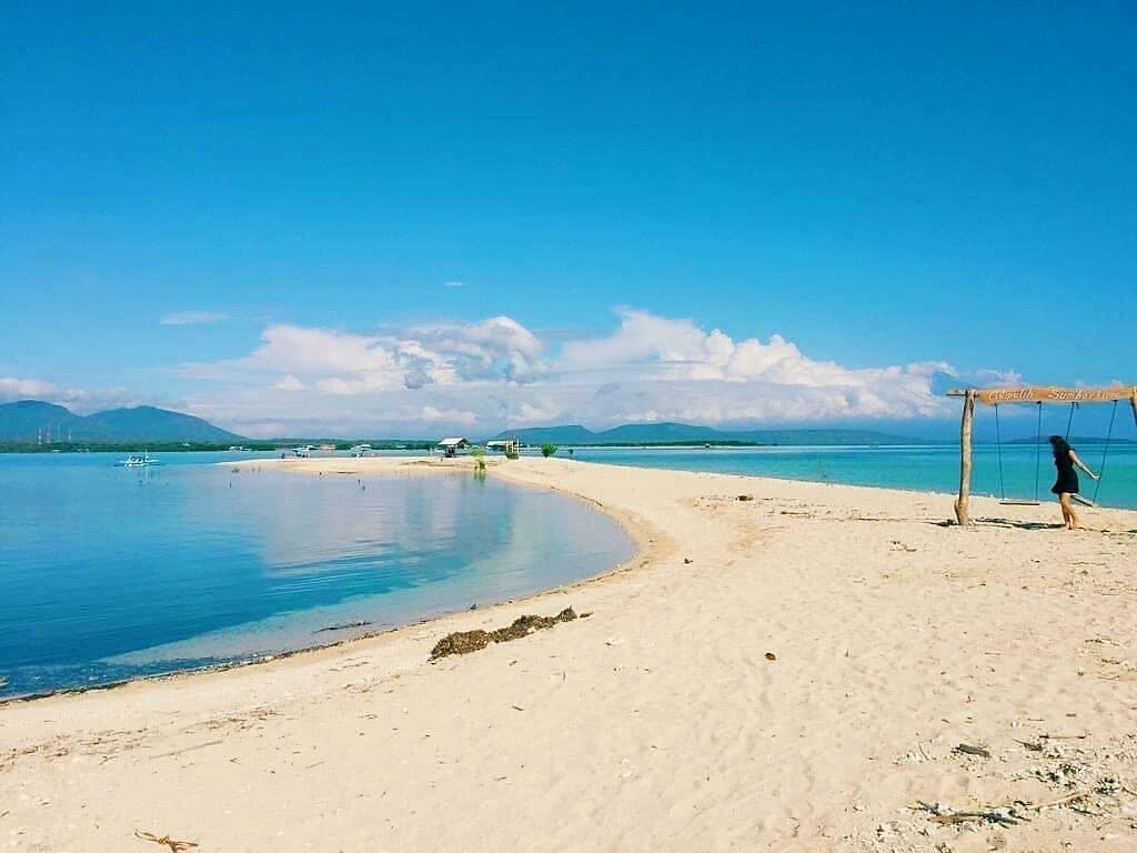 The sandbar's long spit and one of the village group's swings on Gili Putih. Photo: Palm Living.
Its Size Follows the Tide
Sources agree on low tide and differ a little on high tide.
- Low tide: the sand spreads to between one and three hectares, by both the village profile and IDN Times Bali.
- High tide: the village profile puts what stays dry at about 600 square metres. IDN Times gives about 500.
The profile calls Gili Putih land that rises at low tide and sinks at high tide. For a visitor, the practical point is simple. The beach you land on at noon may be a strip by late afternoon.
Sumberkima Is Named After a Spring Found in Kima Shells
The village behind the sandbar has a sea story of its own.
The Sumberkima village website tells it from the memories of its elders. Around 1936 the land here was still forest. A Bugis sailor from South Sulawesi and his crew anchored at a cape ringed with white sand, still called Tanjung Rijasa, in Pegametan.
They found no fresh water. Searching the shore, they came on water spurting up through broken kima shells, a kind of giant clam. It tasted fresh, though the sea was all around it.
They kept coming back for it and called the place Sumber Kima, the kima spring. The spring still shows at low tide, the village says, in the hamlet of Mandar Sari. That is the same hamlet as Bangsal harbour, where the boats to Gili Putih leave.
Bali Express adds that a monument now marks the spring. The village holds the Penangluk Merana ceremony there on Tilem Sasih Keenam, the dark moon of the sixth Balinese month.
The village grew from many places. Its customary profile records newcomers from Bugis country in Sulawesi and from Seraya in Karangasem, east Bali, who settled the forest around 1940. Over time they formed one customary village under Balinese adat law. In 1957 Sumberkima was the centre of a wider village that also took in Pejarakan, Sumberklampok and Pemuteran.
Reach It by Boat from Bangsal, or on Foot at Low Tide
There are two ways out, and the tide decides between them.
By boat. Boats leave from Bangsal harbour, also called Sumberkima Bay, in Banjar Dinas Mandar Sari. The village website lists speedboats and small wooden sampan waiting there, about 10 minutes from the sand. IDN Times Bali describes it as follows:
-
You hire a local fisherman's boat at the harbour, by the boat, for a group of five or six.
-
The crossing takes 10 to 15 minutes.
-
The fare covers the return trip, and the boat waits for you on Gili Putih for about two hours.
On foot. At low tide, the culture and tourism office says, you can walk out from the edge of Pegametan beach, about 1.5 kilometres. When the tide is in, the boat is the way across. A 2019 report by the same office names morning or late afternoon as the time to feel you are walking on water.
Getting to Sumberkima
Bangsal harbour is about half an hour's drive from Gilimanuk port, RRI reports. That makes Gili Putih an easy first stop if you arrive from Java (see the Gilimanuk crossing). From Lovina, Sumberkima is about 45 kilometres west along the coast, by Wikipedia's count.
The regency's Visit North Bali listing carries the map pin and the sandbar's own contact.
The Sea Around Gili Putih Is Being Replanted with Coral
You pass the coral nursery on the boat ride out.
The culture and tourism office describes coral-planting frames in the Sumberkima sea, along the route from Sumberkima Bay. New coral grows on them and becomes a home for fish, turtles and other sea life. The work is a village innovation programme with Yayasan Metamorfosa, a local foundation for marine conservation.
Others have joined in:
- 2021: Indonesia's Ministry of Marine Affairs and Fisheries gave the group, Yayasan Terumbu Karang Metamorfosa, five sets of diving gear and coral-monitoring equipment. The ministry calls it a community conservation group based in Sumberkima.
- April 2025: InJourney Aviation Services, a state-owned company, planted 1,000 coral units at Gili Putih with the foundation in April.
- 2026: Undiksha, the university in Singaraja, planted mangroves on the Sumberkima shore in January, ANTARA reported. The same day it cleaned the beach and released turtle hatchlings at Gili Putih.
The regency's listing names snorkelling and diving over the reefs among things to do. For the wider reef coast, see snorkelling in north Bali.
Fishermen Still Work the Water, and Hold a Contest Here Each August
Gili Putih is also a fishing ground.
Sumberkima's fishermen fish the waters around the sandbar, the village profile notes. Their catch includes tuna, Spanish mackerel and snapper. Some villagers also gather seaweed and shellfish.
The sea has its own temple. Pura Puseh Segara, near the harbour and the beach, honours Ida Bhatara Baruna, lord of the sea. From time to time the village holds a sedekah laut there. Offerings are floated out to sea in thanks for the catch, with prayers for the fishermen's safety, though not every year.
In August, for Indonesia's Independence Day, the village government holds a fishing contest on Gili Putih. On 18 August 2024 the village reported a winning catch of 7.94 kilograms. The heaviest single fish weighed 0.83 kilograms.
How to Fit It In
Gili Putih is a short outing, so it pairs well with a longer day on the water.
The 2019 tourism-office report calls it a usual stop on the way across to Menjangan Island. Sumberkima is also among the national park's listed departure points for Menjangan. The reefs of Pemuteran are next door, and Pura Pulaki stands on the coast road east of Pemuteran.
For the land side of the north-west corner, start with West Bali National Park.
Practical Notes
- Check the tide first. It decides whether you walk or take the boat, and how much sand you get.
- Settle the boat before you leave: the group size, the return trip and the pick-up time.
- Bring water and sun cover. The listing mentions food stalls, but RRI warns the sand gets very hot at midday, with few trees for shade.
- Keep off the coral. The frames along the boat route are a working nursery.
- Take your rubbish back. The village wants the sandbar kept natural.
- In August, expect the fishing contest around Independence Day.
FAQ
What is Gili Putih? A natural sandbar of white sand in the sea off Sumberkima village, in Gerokgak district on Bali's north-west coast. Its name means "white island". It grows to one to three hectares at low tide and shrinks to a few hundred square metres at high tide.
Where is Gili Putih Sumberkima? Off Sumberkima, west of Pemuteran in Buleleng regency. Boats leave from Bangsal harbour, also called Sumberkima Bay, about half an hour's drive from Gilimanuk port. The regency's Visit North Bali listing has a map pin.
How do you get to Gili Putih? By boat from Bangsal harbour, 10 to 15 minutes, hired by the boat for the return trip. At low tide you can also walk about 1.5 kilometres from Pegametan beach.
Does Gili Putih disappear at high tide? Not completely. The village profile puts the dry sand at high tide at about 600 square metres, and IDN Times Bali gives about 500. At low tide it spreads to one to three hectares.
Can you snorkel at Gili Putih? Yes. The regency lists snorkelling and diving over the reefs, and the village profile adds swimming and fishing. Coral is being replanted along the boat route, so keep your fins off it.
Is Gili Putih the same as the Gili islands near Lombok? No. Gili Putih is in Bali, off Sumberkima in Buleleng. IDN Times Bali notes that Bali has a gili of its own, as well as those in West Nusa Tenggara.
Sources
- Desa Adat Sumberkima, Profil Sosial Desa Adat Sumberkima, published by the Bali provincial government, April 2025, for how the sandbar formed, its size, the mangrove attempt, the managing group, fishing, Pura Puseh Segara, the sedekah laut and the village's settlement, read October 2026 (in Indonesian)
- Buleleng Culture and Tourism Office, Wisata Bahari Desa Sumberkima, May 2023, for the sand's origin, the walk from Pegametan, the boats from Bangsal, the August fishing contest and the coral programme, read October 2026 (in Indonesian)
- Buleleng Culture and Tourism Office, One Day Trip to Gili Putih, February 2019, for the stop on the way to Menjangan and the best time to walk, read October 2026 (in Indonesian)
- Buleleng Regency, Visit North Bali, Gili Putih Sumberkima, for the map pin, contact, snorkelling, diving and food stalls, read October 2026 (in English)
- Sumberkima Village, Sejarah Desa, Objek Wisata Gili Putih and Perlombaan Mancing, for the founding story, the boats and the 2024 contest, read October 2026 (in Indonesian)
- Bali Express, Sejarah Desa Sumberkima, for the monument and the Penangluk Merana ceremony, read October 2026 (in Indonesian)
- IDN Times Bali, Harga Tiket Menyeberang Gili Putih Sumberkima, January 2024, for how the boat hire works and the sandbar's size, read October 2026 (in Indonesian)
- RRI Singaraja, Gili Putih Sumberkima, Pulau Eksotis di Bali Utara, August 2024, for the drive from Gilimanuk, read October 2026 (in Indonesian)
- Ministry of Marine Affairs and Fisheries, Masyarakat Buleleng terima bantuan KOMPAK, June 2021, read October 2026 (in Indonesian)
- InJourney Aviation Services, Penanaman terumbu karang di Gili Putih Sumberkima, April 2025, read October 2026 (in Indonesian)
- ANTARA, Undiksha tanam mangrove di pesisir Sumberkima, January 2026, read October 2026 (in Indonesian)
- Wikipedia, Sumberkima, for the distance to Lovina, read October 2026 (in English)
Read next: the best beaches in north Bali, Menjangan Island and Pemuteran.