On this page
- In Brief
- North Bali Beaches at a Glance
- The North Coast Is Swimming and Snorkelling Country
- Which Beach for Which Day
- Lovina (Kalibukbuk): Dolphins at Dawn and an Easy Swim
- Kaliasem and Temukus: Lovina's Quieter Edges
- Pemuteran: A Coral Trail You Can Swim To
- Gili Putih: A White Sandbar off Sumberkima
- Menjangan Island: White Sand and Wall Dives, by Boat
- Banyuwedang: A Hot Spring on the Shore
- Air Sanih (Yeh Sanih): Freshwater Pools Beside the Sea
- Tejakula: Empty Coves East of Singaraja
- Les: A Working Fishing Beach with a Well-Kept Reef
- When to Go: April to October for the Calmest Water
- Getting Around: One Coast Road Links the Beaches
- Practical Notes
- FAQ
- Sources
In Brief
North Bali beaches are for swimming and snorkelling in flat water, with few other people on the sand. Go to Lovina (Kalibukbuk) for dolphins and easy swimming. Go to Pemuteran for a quiet bay with a reef-restoration trail just offshore.
The rare white sand is offshore, on Menjangan Island and the Gili Putih sandbar. The coves around Tejakula and Les are for snorkelling with few people around. Come for the swimming and the snorkelling, because there is no surf and no beach-club strip.
North Bali Beaches at a Glance
- Sand: black to grey volcanic sand on the mainland. White sand only offshore, on Menjangan and Gili Putih.
- Water: calm and protected along most of the coast. Real swimming, gentle for kids, almost no surf.
- Best for: dolphin trips, snorkelling, swimming, quiet.
- Not for: surfing, beach clubs, nightlife.
- Main hubs: Lovina (Kalibukbuk), about 9 km west of Singaraja, and Pemuteran, further west on the same coast road towards the national park.
- Best time: the dry season, roughly April to October, for the calmest water.
- Crowds: light year round, even at Lovina.
- Getting around: a scooter or a private driver. The coast road links almost everything.
The North Coast Is Swimming and Snorkelling Country
The water here is flat enough to swim straight out into, with no long white-sand bays and no surf breaks.
The sand runs dark because the island is volcanic, and on most mornings you can have a stretch of beach to yourself. What north Bali is like explains why this coast is so calm and dry.
The Buleleng tourism office lists five places on this coast for a mask and snorkel:
- Menjangan Island
- the Biorock reef at Pemuteran
- the calm shallows off Lovina
- the villages of Les and Bondalem, near Tejakula
- the Gili Putih sandbar
The beaches below start at Lovina, go west to the national park and then east to Les. The north Bali travel guide maps how they connect.
Which Beach for Which Day
| If you want... | Go to |
|---|---|
| Dolphins at dawn and an easy swim | Lovina (Kalibukbuk) |
| The same calm sand with fewer people | Kaliasem and Temukus |
| A reef you can swim to from the beach | Pemuteran |
| White sand | Gili Putih or Menjangan Island |
| Clear water and wall dives | Menjangan Island |
| A hot soak on the shore | Banyuwedang |
| Freshwater pools, one shallow enough for small children | Air Sanih |
| Empty coves and your own snorkel gear | Tejakula, Les and Bondalem |
Lovina (Kalibukbuk): Dolphins at Dawn and an Easy Swim
Lovina is the north coast's main beach and the one most visitors reach first.
The Buleleng tourism office describes it plainly: black sand, a natural shoreline lined with traditional fishing boats, and sea that is relatively calm. It is an easy beach to swim from and a good one for families. The office calls the water safe for beginners and children to snorkel close to shore.
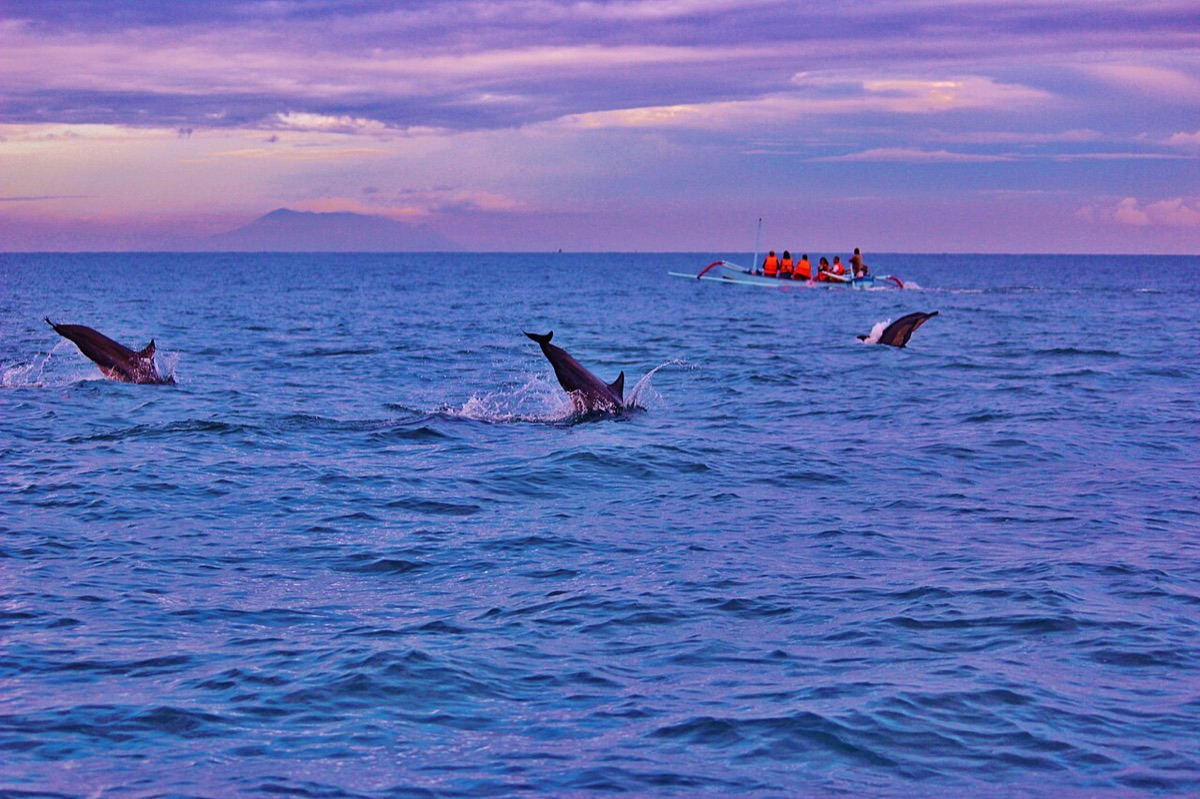 Calm dry-season dawn on the Lovina dolphin water. Photo: Michelle Maria / Wikimedia Commons (CC BY 3.0)
The Dolphin Boats Leave Before Sunrise
Fishermen take visitors out in their outrigger boats before sunrise. The dolphins usually show in the first couple of hours of daylight, a few kilometres offshore. A James Cook University study found them 3 to 4 km from the shore. The whole trip takes around two hours, and by mid-morning the beach is quiet again.
The boats, the etiquette and how to choose an operator are in the Lovina dolphins guide.
What to Know About Lovina
Lovina will not win a white-sand contest, and the dolphin trips draw a small flotilla in peak season. As a base, it puts food, swimming and dolphins on the doorstep.
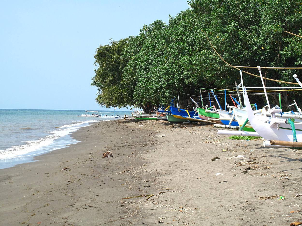 The beach at Lovina, dark sand and a calm sea, with outrigger boats drawn up under the trees. Photo: Ken Eckert / Wikimedia Commons (CC BY-SA 4.0)
Where: Kalibukbuk, the central village of Lovina, about 9 km west of Singaraja. Full detail in the Lovina beach guide. Map
Kaliasem and Temukus: Lovina's Quieter Edges
West of the central Kalibukbuk strip, the villages of Kaliasem and Temukus have the same calm black sand with fewer people.
The swimming is just as gentle, the beachfront is more local and the pace is slower. If Kalibukbuk feels a touch busy at dawn, walk west and you will find empty sand quickly.
These villages are the quieter shoulders of Lovina, worth knowing if solitude matters more to you than a warung every few metres. Kaliasem is also where the Lovina Sunday Market was launched, on the beach in front of Spice Beach Club.
If you want to wake up on this sand, Palm Living's beachfront villas are on this coast around Lovina.
Where: immediately west of central Lovina, walkable along the beach or a short ride down the coast road. Map
Pemuteran: A Coral Trail You Can Swim To
Pemuteran is the quiet end of north Bali, well west of Lovina near the national park.
Its bay has large areas of shallow reef with no strong currents or waves, in the words of the reef-restoration group Karang Lestari. Since June 2000, the village and its partners have installed more than sixty Biorock structures there. These are steel frames carrying a low electric current, and corals grow on them quickly.
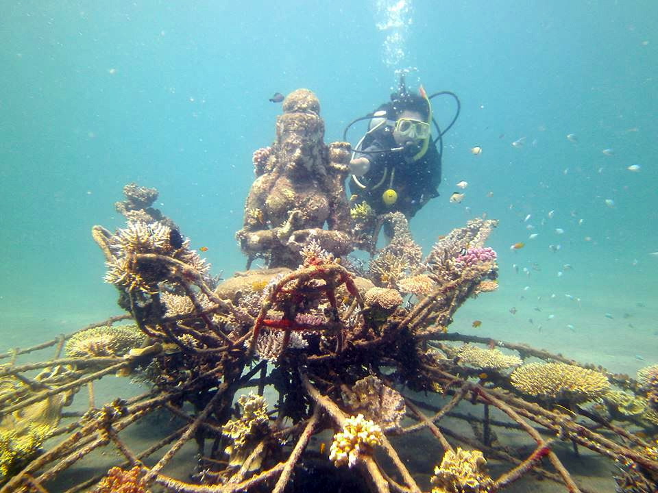 A Biorock structure in Pemuteran bay, coral climbing the frame the village built. Photo: Ennio morricone / Wikimedia Commons (CC BY-SA 3.0)
The structures cover about two hectares of the village's marine protected area. They sit roughly in a line parallel to the shore, 50 to 100 metres out, in water 3 to 7 metres deep. That makes a natural snorkelling trail you can swim out to from the beach.
Choose this beach if you want to do nothing but swim, snorkel and read. It is far from everything, which is the point. Dive and snorkel operators are in Pemuteran diving and snorkelling.
Where: Pemuteran village, Gerokgak district, far northwest Bali. See the Pemuteran guide. Map
Gili Putih: A White Sandbar off Sumberkima
Gili Putih, "white island", is barely an island at all.
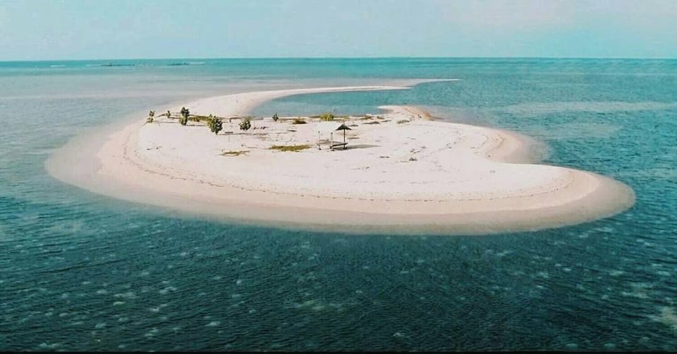 Gili Putih from the air, a hook of white sand off Sumberkima. Photo: Palm Living.
It is a bank of pale sand that rises out of the sea near Bangsal harbour in Sumberkima village, Gerokgak, a short way west of Pemuteran. Like any sandbar, it changes size and shape with the tide. On a coast of black and grey sand, it is a rare patch of white.
A village tourism group, Pokdarwis Kima Bahari Mandasari, looks after it. The group has planted a few trees and put up swings and gazebos for shade and photographs. From the sand you look back at the mountains of Bali and across to Java.
The water around it is clear enough to swim and snorkel, with coral in places and starfish often visible in the shallows. The Buleleng tourism office lists it among the coast's snorkelling spots.
Plan It as a Photo Stop and a Swim
Gili Putih is an hour or two on a strip of sand. Before you set off:
- Boats cross from Bangsal harbour. Agree the price for the boat, and when you will be collected.
- Ask what the tide is doing.
- Go early or late in the day, not at midday, because there is very little shade.
- Take water, a hat and reef-safe sunscreen.
- Bring your rubbish back.
Where: off Bangsal harbour, Sumberkima village, Gerokgak, west of Pemuteran. It pairs easily with a morning on the Pemuteran reefs or a Menjangan trip. Map
Menjangan Island: White Sand and Wall Dives, by Boat
Menjangan is a small, uninhabited island inside West Bali National Park. It is named for the wild deer that live on it, and it is dotted with temples.
The village of Pejarakan, whose coast faces the island, describes the first sight from the boat as a white-sand beach with temples above it. These beaches are the closest the north gets to classic white sand.
The water around them is the reason people come. The Buleleng tourism office calls Menjangan a world-class diving and snorkelling destination, with clear water, healthy reef and wall dives.
You come by boat for the day. For snorkelling and diving, this is one of the best-known stretches of water on the north coast. The Menjangan Island guide covers the boats, the park permits and the reef.
For lying on a beach, the mainland calm-water coves are easier to reach.
Where: West Bali National Park. Most boats cross from Banyumandi harbour at Batu Ampar in Pejarakan village, or from Labuhan Lalang in Sumberklampok. The crossing takes around 45 minutes. Map
Banyuwedang: A Hot Spring on the Shore
Banyuwedang is a sheltered, mangrove-fringed bay on the far northwest of the coast, at the edge of the national park. It is best known for its hot spring.
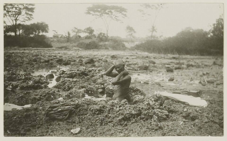 A bather in one of the hot wells on the shore of Banyuwedang bay, photographed around 1920. Photo: Unknown author, KITLV / Leiden University Libraries / Wikimedia Commons (CC BY 4.0)
The spring rises on the shore itself and goes under the sea at high tide. A round concrete wall has been built around it to keep the salt water out.
The water is sulphurous, with a stronger smell than the springs at Banjar. The Pejarakan village site puts its temperature at close to 45°C. Local visitors come to bathe, and some come to pray and take a melukat, a purifying bath.
Treat this as a stop more than a sunbathing beach. A soak here pairs with a Menjangan day, since the harbours are close by. If you would like landscaped pools, the Banjar hot springs near Lovina are the easier choice.
Where: Banyuwedang, Pejarakan village, on the Singaraja to Gilimanuk road at the edge of West Bali National Park. Map
Air Sanih (Yeh Sanih): Freshwater Pools Beside the Sea
Air Sanih sits on the coast road east of Singaraja, in Kubutambahan district. A freshwater spring there feeds two stone-walled pools a few metres from the sea.
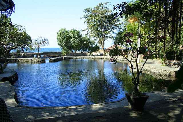 The large spring-fed pool at Air Sanih, with the sea just beyond its far wall. Photo: Palm Living.
Yeh is Balinese for water, and Sanih is the village. The fresh water does not mix with the salt, and in the village's understanding it flows underground from Mount Batur.
The larger pool is deep enough for adults to swim, and the smaller one is shallow enough for small children. The village runs the place.
Two things to know before you go. The village closes the pools for its own purification ceremony, a local day of silence held every two years, so check before a special trip. The beach alone would not justify the journey. The springs and the calm bay together make a pleasant break on the coast road, especially towards evening.
Where: Sanih, Kubutambahan district, on the coast road east of Singaraja. Map
Tejakula: Empty Coves East of Singaraja
East of Singaraja, the coast turns wild and little travelled.
Around Tejakula, small coves of volcanic sand sit below quiet fishing villages. The Buleleng tourism office names the neighbouring villages of Les and Bondalem as the coast's snorkelling spots for anemones, reef fish and well-preserved coral. There is little here in the way of facilities, which is part of why the sand stays empty.
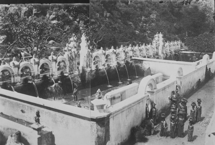 The Tejakula bathing place, photographed around 1900. Photo: Tropenmuseum / Wikimedia Commons (CC BY-SA 3.0)
The old village bathing place at Tejakula is worth a look on the way through. Once known as the Horse Bath, it was built under the Dutch, and the village says its water comes from the lake at Batur. More on the village is in the Tejakula guide.
Come here for the version of the north coast that feels undiscovered. Bring your own snorkel gear and water, because services are thin.
Where: Tejakula district, east of Singaraja along the coast road towards Amed. Map
Les: A Working Fishing Beach with a Well-Kept Reef
Les is a fishing village a little further east, known for the tall Yeh Mampeh waterfall just inland.
The village's own tourism listing puts its reef first among the things to see underwater. It calls the reef "very well preserved and maintained by a group of marine coral observers." The village also offers tuna-fishing trips with local fishermen.
That tells you what the shore is: a working beach with boats pulled up on it. It suits people who like a place with a pulse to it, fishermen and all. Fold the Yeh Mampeh waterfall into the same trip.
Where: Les village, Tejakula district, with Yeh Mampeh waterfall a short drive inland. Map
When to Go: April to October for the Calmest Water
The dry season, roughly April to October, brings the calmest water.
Crowds are light all year. The busiest sight is the dolphin flotilla off Lovina in peak season, and it is over by mid-morning. On the exposed sand of Gili Putih, go early or late in the day.
Getting Around: One Coast Road Links the Beaches
A scooter or a private driver is the way to move between beaches, because the coast road links almost everything.
Lovina is about 9 km west of Singaraja, and Pemuteran is further west on the same road towards the national park. Menjangan and Gili Putih are reached by boat from the harbours at that western end.
The north Bali travel guide and the three-day north Bali itinerary show how these beaches fit into a longer trip, with the waterfalls and hot springs inland. If you are comparing coasts before you commit, the best beaches in Bali guide sets the north beside the white sand of the south and east.
Practical Notes
- Hot sand: the dark sand holds heat at midday, so wear sandals.
- Boats: agree the price and the pick-up time before you leave the harbour.
- Snorkel gear: bring your own to Tejakula and Les, along with water, because services are thin.
- Air Sanih: the village closes the pools for its purification ceremony every two years, so check first.
FAQ
What are the best beaches in north Bali? Lovina (Kalibukbuk) for dolphins and easy swimming, and Pemuteran for its quiet bay and reef-restoration trail. Menjangan Island is the place for snorkelling and diving, and Gili Putih for a white sandbar. The coves around Tejakula and Les have empty beaches with reef close to shore. The mainland beaches have calm water and black sand.
Why is the sand black on north Bali beaches? Bali is a volcanic island, and the north coast sand is ground-down volcanic rock, which runs from dark grey to near-black. It holds heat in the midday sun, so sandals help.
Can you swim at north Bali beaches? Yes. The north coast is protected, with calm, flat water and almost no surf along most of the shore. Lovina in particular is gentle enough for children, and the Buleleng tourism office calls its water safe for beginners to snorkel.
Are there white-sand beaches in north Bali? Not on the mainland, which is volcanic black and grey sand. The white sand is offshore, on Menjangan Island, in West Bali National Park, and on Gili Putih, a small tidal sandbar off Sumberkima near Pemuteran.
Which north Bali beach is best for snorkelling? The Buleleng tourism office lists Menjangan Island, the Biorock reef at Pemuteran, Lovina, Les and Bondalem near Tejakula, and Gili Putih. Menjangan has clear water and the wall dives. Pemuteran has reef you can swim to from the beach, and Lovina is gentle for beginners.
What is Gili Putih in Sumberkima? A small white sandbar in the sea near Bangsal harbour in Sumberkima village, west of Pemuteran, that changes shape with the tide. A village tourism group looks after it, with a few trees, swings and gazebos. Boats cross from the harbour. Agree the price and pick-up time before you go, and bring water and sun protection.
Where can you see dolphins in north Bali? Off Lovina. Fishermen take visitors out before sunrise, and the dolphins usually surface in the first couple of hours of daylight, a few kilometres offshore. The Lovina dolphins guide covers it in full.
Sources
- Buleleng Regency tourism office (Visit North Bali), Snorkeling (Menjangan, Pemuteran, Lovina, Les and Bondalem, Gili Putih), read September 2026
- Buleleng Regency tourism office, Kalibukbuk Village (Lovina's black sand, fishing boats, calm water, dolphin trips), read September 2026
- Buleleng District Government, Indahnya Destinasi Pantai Lovina (Lovina's distance from Singaraja), in Indonesian, read September 2026
- Karang Lestari Pemuteran, About Us (the Biorock project, its size, depth and distance from shore), read September 2026
- RRI (Radio Republik Indonesia), Gili Putih Sumberkima, pulau eksotis di Bali Utara, 31 August 2024 (location, the managing group, facilities, best time of day), in Indonesian, read September 2026
- Pejarakan Village, Pulau Menjangan, surga tersembunyi di Bali Barat (the island, its beach and temples, the departure harbours) and Pemandian Air Panas Banyuwedang (temperature, sulphur, melukat), in Indonesian, read September 2026
- Buleleng Culture and Tourism Office, Banyuwedang, tempat menikmati air panas di tepi laut Buleleng (the shoreline spring, the sea wall, mangroves), in Indonesian, read September 2026
- Buleleng Regency tourism office, Tejakula Tourism Village and Les Tourism Village, read September 2026
- Buleleng Communications Office, Pemandian air tawar di tepian pantai (Yeh Sanih's spring, pools and purification closure), in Indonesian, read September 2026
- Buleleng Culture and Tourism Office, Sejarah Lovina (Lovina about 9 km west of Singaraja), in Indonesian, read October 2026
- Putu Liza Kusuma Mustika, James Cook University, Towards Sustainable Dolphin Watching Tourism in Lovina, Bali, Indonesia, thesis abstract on Australia Awards in Indonesia (dolphins found 3 to 4 km from the shore), read October 2026
Staying on the coast: the best villas in Lovina and where to stay in north Bali. Palm Living's villas for rent are around Lovina.