On this page
In Brief
Buleleng Regency (Kabupaten Buleleng) is the administrative region that covers Bali's north coast and the hills behind it. It is the largest of Bali's nine regencies and cities, about a quarter of the island, and its capital is Singaraja. The regency is divided into nine districts (kecamatan): Gerokgak, Seririt, Busungbiu, Banjar, Sukasada, Buleleng, Sawan, Kubutambahan and Tejakula. Lovina, Munduk and its lakes, Pemuteran, Menjangan Island, the Sekumpul and Gitgit waterfalls and the Banjar hot springs are all inside it. Two places often sold as north Bali are not: Bedugul and Lake Beratan belong to Tabanan, and Amed to Karangasem.
Buleleng at a Glance
- What it is: One of Bali's regencies, a kabupaten, run from Singaraja
- Size: 1,365.88 km² by the regency's own profile, about a quarter of Bali; the statistics office's 2024 handbook, using Home Affairs Ministry figures, gives 1,322.68 km²
- Coast: 157 km along the Bali Sea; every district except Busungbiu and Sukasada reaches the sea
- Districts: Nine, holding 129 villages (desa) and 19 urban wards (kelurahan)
- Neighbours: Jembrana to the west and south, with Tabanan, Badung and Bangli also to the south, and Karangasem to the east
- Highest point: Gunung Tapak, 1,903 metres, in Sukasada district
- Lakes: Buyan, in Sukasada, and Tamblingan, in Banjar
- Islands: Besides its share of Bali, the regency counts Menjangan and Tabuhan as its land
Buleleng and "North Bali"
The name works on three levels, which is why it confuses people. Buleleng was a kingdom, it is today's regency, and it is also the name of one of the regency's nine districts, the small one that holds Singaraja. A sign or an address reading "Buleleng" can mean any of the three.
The kingdom came first. The regency's own history names Ki Gusti Ngurah Panji Sakti as its founder and gives 30 March 1604 as the day he built a new palace on fields where people grew buleleng, and called it Singaraja for his lion-like courage. The same account calls the north by its older name, Den Bukit. The long story of the kingdom, the Dutch and the colonial capital is told in a brief history of north Bali; this page stays with the present.
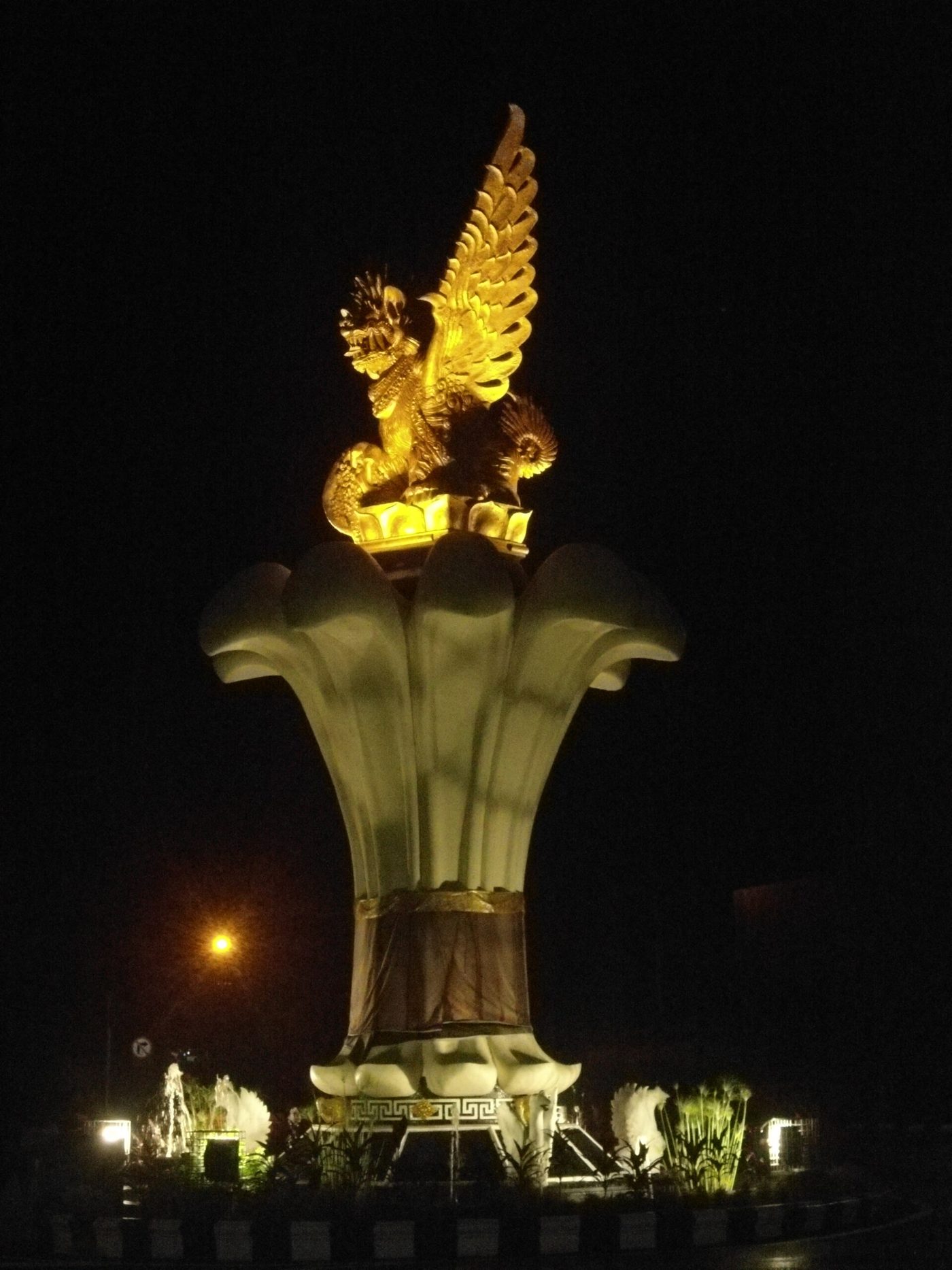 Singa Ambara Raja, the winged lion at the centre of Singaraja, the regency's capital. Photo: DayakSibiriak / Wikimedia Commons (CC BY-SA 4.0)
"North Bali" is a traveller's phrase with softer edges. Nearly everything it usually covers is inside Buleleng, but two favourites sit across the line. Bedugul and Lake Beratan, with the lake temple, are in Tabanan regency: the provincial government's Love Bali directory places Ulun Danu Beratan at Candikuning, Tabanan, and it appears in Tabanan's own tourism listings. The two lakes just north of it, Buyan and Tamblingan, are Buleleng. Amed, on the east coast, belongs to Abang district in Karangasem, whose tourism office lists its salt makers and snorkelling. The Bedugul guide and the Amed guide cover both.
The regency describes its own shape as nyegara gunung, sea and mountain. Most of it is hill country rising to the south, with a narrow strip of low ground along the coast where the towns and the main road are.
The Nine Districts
The statistics office lists the districts in this order, which runs roughly from west to east. Busungbiu and Sukasada are the two inland districts, behind Seririt and Singaraja.
| District | Capital | On the coast? | What a visitor knows it for |
|---|---|---|---|
| Gerokgak | Gerokgak | Yes, the longest coastline of any district in Bali | Pemuteran, Menjangan Island, Pura Pulaki |
| Seririt | Seririt | Yes | Seririt market town, Umeanyar, the road to Pupuan |
| Busungbiu | Busungbiu | No | Hill country south of Seririt, its villages mostly on slopes and in valleys |
| Banjar | Banjar | Yes | Banjar hot springs, the Buddhist monastery, Munduk, Lake Tamblingan |
| Sukasada | Sukasada | No | Gitgit and Aling-Aling waterfalls, Lake Buyan, Pancasari |
| Buleleng | Singaraja | Yes | Singaraja, and Lovina beach at Kalibukbuk |
| Sawan | Sawan | Yes | Sekumpul waterfall |
| Kubutambahan | Kubutambahan | Yes | Pura Maduwe Karang, the Air Sanih spring |
| Tejakula | Tejakula | Yes | Tejakula village, Les |
Gerokgak is the biggest district, a little over a quarter of the regency, with 76.89 km of shore. Buleleng district is the smallest, about 3.4 percent of the land, and holds the largest share of the people.
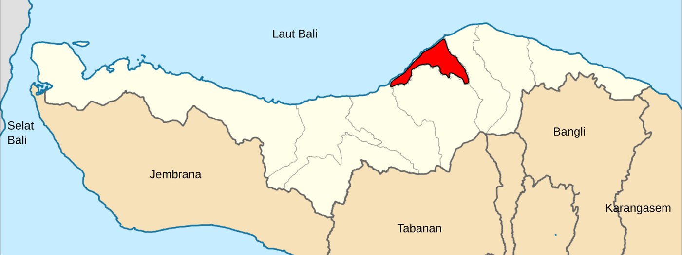 Buleleng district, the smallest of the nine, in red; the rest of the regency is the pale strip along the north. Map cropped. Photo: Joseagush / Wikimedia Commons (CC BY-SA 4.0)
Where Visitors Go, District by District
Lovina and Singaraja
Lovina beach is in Kalibukbuk village, Buleleng district, about 9 km west of Singaraja. The name was Anak Agung Panji Tisna's, according to the regency's tourism office, which dates Lovina to 1953. The coast, the dolphins and the villages are in the Lovina guide, and the capital itself in Singaraja old town.
Banjar: Hot Springs, a Monastery and Munduk
Banjar district reaches from the coast just west of Lovina's centre up into the highlands. The Banjar hot springs are about 5 km south-west of the Lovina coast, with the Brahmavihara-Arama monastery about 1.5 km away in the same district. Higher up, Munduk village and Lake Tamblingan are in Banjar too; see Munduk and the twin lakes.
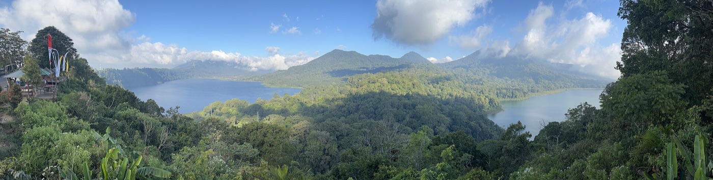 Buyan, in Sukasada district, and Tamblingan, in Banjar, seen together from the ridge. Photo: Stefan Fussan / Wikimedia Commons (CC BY-SA 3.0)
Sukasada and Sawan: the Waterfalls
Gitgit is on the main Bedugul to Singaraja road in Sukasada district, about 11 km from Singaraja, and Aling-Aling is at Sambangan in the same district. Sekumpul is in Sawan district, about 20 km from Singaraja. The north Bali waterfalls guide puts them all on one page.
Gerokgak: Pemuteran, Menjangan and Pulaki
The far west is one district. Pemuteran is about 57 km from Singaraja. Menjangan Island lies offshore inside West Bali National Park, and the sea temple of Pura Pulaki stands on the coast road at Banyupoh.
Seririt
Seririt is the market town where the western road from Pupuan reaches the coast, about 20 km west of Singaraja. It has its own page: Seririt, Bali.
Kubutambahan and Tejakula: the East
East of Singaraja the coast road runs on toward Karangasem. Pura Maduwe Karang at Kubutambahan, begun in 1890 according to the district office, is in the north Bali temples guide, and the Air Sanih spring is at Bukti in the same district. Further on, Les is about 35 km east of Singaraja; the Tejakula guide covers that end of the coast.
Practical Notes
- Reading addresses: "Kec." is kecamatan, the district, and "Kab. Buleleng" is the regency. An address ending "Kec. Banjar, Kab. Buleleng" is in Banjar district, not Banjar village.
- Official listings: The regency tourism office's directory, Visit North Bali, lists attractions, villages and places to stay with their addresses.
- Distances: Everything is measured from Singaraja on official pages. The north Bali map lays the places out west to east.
- Getting there: All roads from the airport cross the mountains; see getting to north Bali.
- Where to stay: Most visitors base themselves on the central coast. Palm Living's villas are mostly around Lovina, in the middle of the regency.
FAQ
What is Buleleng? Buleleng is the regency that covers Bali's north coast and the hills behind it, with Singaraja as its capital. The name also belongs to the old kingdom of the north and to one of the regency's nine districts, the one that contains Singaraja.
Is Buleleng the same as north Bali? Almost. Lovina, Singaraja, Munduk, Pemuteran, Menjangan, Sekumpul and Tejakula are all in Buleleng. Bedugul and Lake Beratan are in Tabanan regency, and Amed is in Karangasem, even though travel writing often calls them north Bali.
What is the capital of Buleleng Regency? Singaraja. It sits in Buleleng district on the central coast, about 9 km east of Lovina, and was founded, by the regency's own account, in 1604.
How many districts are there in Buleleng? Nine: Gerokgak, Seririt, Busungbiu, Banjar, Sukasada, Buleleng, Sawan, Kubutambahan and Tejakula. Together they hold 129 villages and 19 urban wards.
Is Lovina in Buleleng? Yes. Lovina beach is in Kalibukbuk village, Buleleng district, about 9 km west of Singaraja, and the coast around it is the most common base for visitors to the regency.
What is the biggest district in Buleleng? Gerokgak, in the far west, with a little over a quarter of the regency's land and the longest coastline of any district in Bali. It holds Pemuteran, Pura Pulaki and Menjangan Island.
Sources
- Buleleng Regency government, Geografis dan Iklim (area, the three islands, 157.05 km of coast, Gerokgak's 76.89 km, the two inland districts, Gunung Tapak, the lakes and their districts), Indonesian, read September 2026
- Buleleng Regency government, Pemerintahan (nine districts, 129 villages and 19 wards, villages per district), Indonesian, read September 2026
- Buleleng Regency government, Sejarah Kota Singaraja (Ki Gusti Ngurah Panji Sakti, Den Bukit, the palace of 30 March 1604 and the name Singaraja), Indonesian, read September 2026
- Buleleng research and innovation agency, Selayang Pandang Kabupaten Buleleng (largest of Bali's nine regencies and cities, nyegara gunung, district shares of land and population) and Luas Wilayah Kecamatan (area of each district), Indonesian, read September 2026
- BPS Buleleng (Statistics Indonesia), Indikator Statistik Esensial Kabupaten Buleleng 2024 (PDF: borders, district capitals, villages and wards per district, the 1,322.68 km² figure), Indonesian, read September 2026
- Buleleng tourism office, Sejarah Lovina (Lovina about 9 km west of Singaraja, named by Anak Agung Panji Tisna in 1953) and Muter-muter Desa Pemuteran (Pemuteran about 57 km from Singaraja), Indonesian, read September 2026
- Visit North Bali, the regency tourism directory: Lovina Beach, Banjar Hot Spring, Gitgit Waterfall, Aling-Aling Waterfall, Tamblingan Lake, Munduk Tourism Village, Pulaki Temple, Air Sanih and Snorkeling Menjangan, English, read September 2026
- Sawan district office, Air Terjun Sekumpul (Sekumpul village, Sawan district, about 20 km from Singaraja), Indonesian, read September 2026
- Kubutambahan district office, Sejarah Pura Madue Karang (the temple begun in 1890), Indonesian, read September 2026
- Tejakula district office, Sejarah Desa Les (Les about 35 km east of Singaraja), Indonesian, read September 2026
- Bali provincial government, Love Bali, Ulun Danu Beratan, and Tabanan tourism office, Ulun Danu Beratan (Bedugul's lake temple in Tabanan regency), read September 2026
- Karangasem tourism office, Kecamatan Abang (Amed in Abang district, Karangasem), Indonesian, read September 2026
Read next: the north Bali map for how the places line up, the complete north Bali travel guide for planning, and a brief history of north Bali for the kingdom behind the name.